Additional information
| Licenses | Dongle Bound License – Unlimited use. |
|---|


$2,099.00
In short Hydromagic is a full service Hydrographic Survey Software from start to finish. Logging and Cleaning data with RTK, Create 2D Matrix with color coded countours. Creata 3D image. A final map complete with all keys and tables. Even surveyors that have drivers for echo sounders on their Trimble or other collection software have upgraded to Hydromagic for the filter and cleaning tools alone.
Purchase options
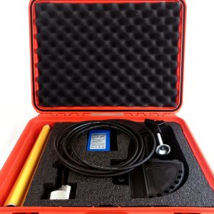
1. Hydromagic Survey – Dongle bound license (including shipping)
including 1 year support and updates $2150 . The Dongle can be moved from PC to PC anytime.
Hydromagic is a professional hydrographic survey package,
which can be used to map depth areas using an echosounder.
The software is very affordable and the learning curve is very short.
You can start creating your first sounding within a single day.
 Support for GPS an
0d RTK receivers
The software can communicate with almost any (NMEA0183 compatible) GPS or RTK receiver to retrieve your current position and height, and show it on one of the support raster or vector maps. In addition, with a RTK receiver, you can calculate tide levels in real-time.
 Support for echosounders
Hydromagic offers support for a wide range of professional single and dual frequency hydrographic echosounders from popular brands like CEE HydroSystems, Odom, STN Atlas, SyQwest and more.
| Licenses | Dongle Bound License – Unlimited use. |
|---|